

I last made this hike in the summer of 2005. I started my hike from the trail head access point at the top of Ryan Gulch Road in the Wildernest development. The hike starts with a very steep climb that is followed by ¾ of mile of scrambling over boulder fields as you make your way around the side of Buffalo Mountain. Unfortunately, during this scramble you are losing a lot of elevation as the trail is generally heading down hill. You break out of the forest in a dramatic fashion as you come across a wide and very long avalanche run on the northeastern side of Buffalo Mountain. The trail re-enters the forest and crosses South Willow Creek and intersects with the Gore Range Trail. About ½ miles after the trail intersection, you come upon one of the hidden gems of this hike – South Willow Falls.
The falls are made up of several narrow plumes eroded in the rock through which the water tumbles downs. The volume of water forced through these narrow plumes is pretty remarkable and the falls are actually quite impressive as the water falls over 50 feet.
After the falls you enter an area of thick scrub willow and scrub oak through which the trail winds. This part of the hike is difficult and you are constantly being snagged by the trees. During my passage through this area, I saw 3 marmots gorging themselves on as much food as they could. The growing season at this altitude is so short that the animals that live there use every hour of the summer to bulk up and prepare for the long brutal winters.
There were signs of numerous avalanche runs descending from both Buffalo Mountain and Red Peak in this area. I know people snowshoe/cross country ski into this area in the winter, but to me it appears too dangerous.
Finally after what seemed to be ages you break out of the scrub willow and oak and emerge into a wonderful world of high alpine meadows filled with small lakes and wildflowers. The pass itself rises up from the “bowl” that forms in the junction between the two mountains. When you are finally at the top of the pass you can see a trail snaking downward into the forests below. If you were to follow this path you would eventually reach Deluge Lake and Gore Creek – from which you have easy access to Vail.

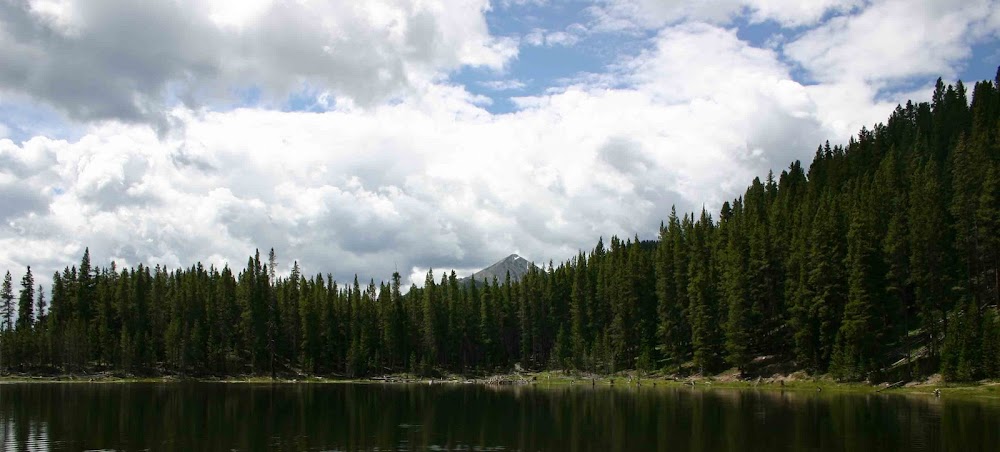
 It took me the better part of the day to reach the pass and to return to the trail head. According to my GPS I logged over 15 miles of hard hiking that day. It was very tiring day that left me exhausted but as you can see from some of the pictures posted in this entry, it was well worth it. I took these pictures with my 35mm Digital SLR.
As for what is going on today – not much except for a lot of work. Things at work are very busy and hectic. Zack had a good day at school and we managed to fit some out door activity after I was done with work and Zack was done with his homework. Before the sun went down we head out and took a couple mile hike on the Lee Gulch Trail in Littleton. I even persuaded Nancy to go out to dinner with us. Nothing fancy we just went out to IHOP, but nonetheless it was the first time I have managed to get Nancy to go out to dinner with us in ages. Going to IHOP was a bit of a mistake as it was “National Pancake Day” and you could get free pancakes – so the place was packed.
Zack did a nice thing when we were there. He had a dollar that Nancy had given him for having a good day at school. (She gives him 50 cents per day that he doesn’t get in trouble.) He took the dollar and put it in the donation kettle for the Shriners who were collecting donations there tonight. How thoughtful was that of the little boy! I am so proud of my little man!
On another note – today is my sister Stephanie’s birthday. Happy Birthday Stephanie!
Thanks and peace to all!
It took me the better part of the day to reach the pass and to return to the trail head. According to my GPS I logged over 15 miles of hard hiking that day. It was very tiring day that left me exhausted but as you can see from some of the pictures posted in this entry, it was well worth it. I took these pictures with my 35mm Digital SLR.
As for what is going on today – not much except for a lot of work. Things at work are very busy and hectic. Zack had a good day at school and we managed to fit some out door activity after I was done with work and Zack was done with his homework. Before the sun went down we head out and took a couple mile hike on the Lee Gulch Trail in Littleton. I even persuaded Nancy to go out to dinner with us. Nothing fancy we just went out to IHOP, but nonetheless it was the first time I have managed to get Nancy to go out to dinner with us in ages. Going to IHOP was a bit of a mistake as it was “National Pancake Day” and you could get free pancakes – so the place was packed.
Zack did a nice thing when we were there. He had a dollar that Nancy had given him for having a good day at school. (She gives him 50 cents per day that he doesn’t get in trouble.) He took the dollar and put it in the donation kettle for the Shriners who were collecting donations there tonight. How thoughtful was that of the little boy! I am so proud of my little man!
On another note – today is my sister Stephanie’s birthday. Happy Birthday Stephanie!
Thanks and peace to all!
No comments:
Post a Comment