A unique feature of Denver that very few people know about are its Mountain Parks. In the early 20th century, the leaders of the young city of Denver concluded that it would be in the city's best interests to preserve tracts of wilderness outside of Denver's boundaries. This decision was driven by the idea of setting aside land that might otherwise be developed so that it could be used by the people of Denver for recreation and to allow the city dwellers to escape into the wilderness. What started in 1910 has continued and grown. There are now 22 properties, holding over 14,000 acres of land that make up the Denver Mountain Parks system. Many of these properties are parks in which trails, picnic shelters and other facilities have been built. A small number of these properties have remained untouched and undeveloped.
Elephant Butte is one of the Denver Mountain Park properties that has remained untouched over all these years. According to everything I could find on the Internet, there are no trails in the Elephant Butte property. In the center of this preserved space is Elephant Butte, which is an 8,400 foot rocky point that looms over the Jefferson County mountain town of Evergreen. Located to the southwest of downtown Evergreen, Elephant Butte is "sandwiched" between Evergreen Lake and the Jefferson County Open Space - Alderfers Three Sisters Park.

Each time I have gone to Alderfer Three Sisters Open Space to hike, I have looked at Elephant Butte in the distance and told myself that someday I was going to climb to the top of it. This past Tuesday, after getting Zack off to the bus, I set out on my journey to climb Elephant Butte.
Driving to Evergreen I encountered the typical morning rush hour traffic along highway C470. It honestly wasn't that bad as Denver's rush hour traffic is no where near as congested as other cities. Thankfully most of my journey was on the winding roads of Bear Creek Canyon. Though traffic was sparse the sharp curves and steep inclines ensured that I kept my speed in check.
I arrived at the parking area of Three Sisters/Alderfer's Open Space and realized based upon the lack of cars that it was pretty likely I would have the trails to myself. Looking towards Elephant Butte to the north, I reminded myself that the looks of a mountain are usually quite deceiving, as it didn't look like it would be a hard climb. Assuming a mountain is an easy climb is a great way to get yourself into trouble!
In preparation for this climb I had done a lot of reading about Elephant Butte. There wasn't one article in which a trail to the top was mentioned. It was going to be an off trail bushwhack to reach the top of this mountain. From the parking area I would strike out on the Bluebird Meadow trail and then link up with Mountain Mulhy trail. Following this trail for about 8/10 of a mile, I would cross Buffalo Creek and then move off trail to cover the last 3/4 of a mile to the summit of Elephant Butte.
The first part of my hike was wonderful as I meandered along the trails. Moving steadily down hill towards Buffalo Creek, I entered a small valley still in the early morning shadows. The cool morning air was still and calm. It seemed as though I had entered a different world removed from the hustle and bustle of the outside world. This sense of peace and calm was further emphasized when I came across a pair of mule deer quietly grazing on the banks of Buffalo Creek. They startled me more than I startled them and I stood there for several long minutes looking at them as they assessed whether I was a danger or not.
Letting the deer to graze in peace, I continued my journey down to the bottom of the valley and Buffalo Creek. Taking a last look at the trail to ensure I could find my way back, I struck off into the bush. I was able to follow a faint path along the pine needle strewn forest floor. Eventually the heavy forest cover and the trail petered out and I found myself along the steep flanks of Elephant Butte.
To climb this mountain, I would need to carefully navigate my way up the steep slopes without putting myself into a perilous situation. The method I use to bushwhack my way up a mountain like this is to "follow the green". That is, I try and follow the areas in which trees and bush grow up the side of the mountain. If a tree or shrub can grow on it, then it usually means that the ground isn't too steep to walk upon - usually.
It seemed like it took forever but I finally arrived at a point on the mountain right below the top slab of the mountain and it was there that I came across a path. Coming across the path was both reassuring and annoying. It was reassuring in the fact that I would be able to get my way off the mountain without having to go back they way I came and it was annoying in the fact that there was obviously a path that ran the whole way up and down the mountain. I spent all the time and put myself in peril to reach this height on the mountain only to find that there was a path the whole way up it!
Following the path to the top was difficult at it was not a formal, well constructed path. There were several points in which the path seemed to fade away but it was because there was an abrupt turn that wasn't marked. Eventually I gave up on the path and got down on my hands and knees and climbed the last several hundred feet to the top.
Obtaining the summit presented a marvelous view in all directions! I could see clearly for many miles. Though the climb had been difficult, it was well worth it because of all the wonderful views.


There were several peak registers in a plastic container stuffed in the hollow of a dead pine tree near the summit. Of course I had to stop and sign the register and read what others who had come before me had written. It is fun to see the thoughts and comments of those who have scaled the mountain.
After spending about 30 minutes enjoying the view at the top, I started back down. Shortly after I left the top I ran into an older gentleman walking towards the summit. We stopped and talked for a short bit and I asked him about the trail. He was able to provide me with a couple of reference points so that I could follow the trail the whole way down. Needless to say that made my return trip down the mountain so much quicker!
To help those who scale Elephant Butte in the future I used my GPS to mark where the informal trail to the top of Elephant Butte starts. This trail branches off of the Mountain Mulhy trail in Alderfer Three Sisters Open Space at these coordinates - N 39.37.736 W 105.21.609. The branch point is not obvious at all and unless you are looking for it, you probably will not find it. If you intend to climb Elephant Butte, use these coordinates as it will make your hike so much easier!
Elephant Butt is just one of the many hikes and climbs that I have been doing in the two weeks since Zack went back to school. I have many more of these hikes planned in the coming days and weeks. As the weather and the leaves begin to change, I'll be heading further into the mountains to see the wonderful colors of autumn.
I hope everyone is enjoying there long weekend and has a great day off tomorrow!
Thanks and peace to all!
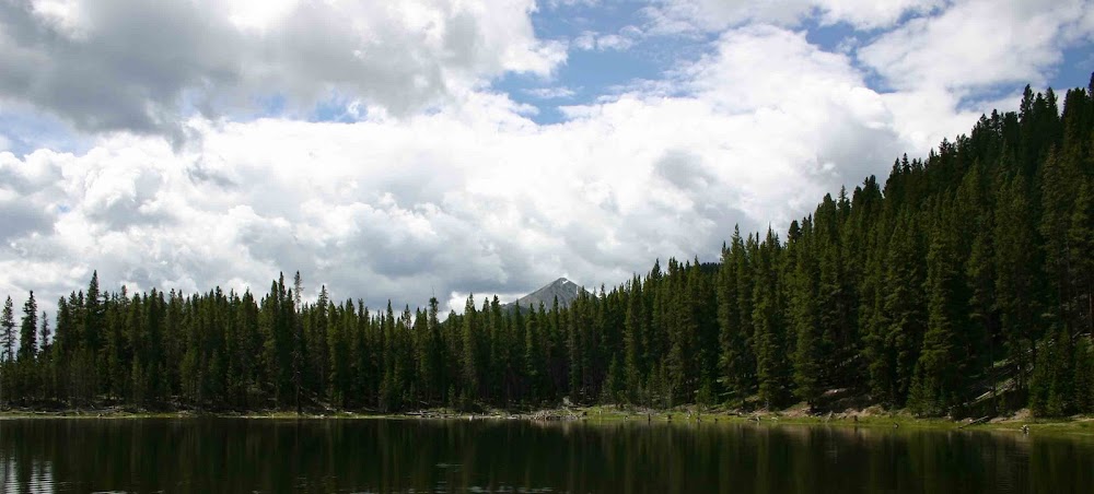
Elephant Butte is one of the Denver Mountain Park properties that has remained untouched over all these years. According to everything I could find on the Internet, there are no trails in the Elephant Butte property. In the center of this preserved space is Elephant Butte, which is an 8,400 foot rocky point that looms over the Jefferson County mountain town of Evergreen. Located to the southwest of downtown Evergreen, Elephant Butte is "sandwiched" between Evergreen Lake and the Jefferson County Open Space - Alderfers Three Sisters Park.

(Elephant Butte as seen from Blue Bird Meadow Trail in the Alderfer Three Sisters Open Space)
Each time I have gone to Alderfer Three Sisters Open Space to hike, I have looked at Elephant Butte in the distance and told myself that someday I was going to climb to the top of it. This past Tuesday, after getting Zack off to the bus, I set out on my journey to climb Elephant Butte.
Driving to Evergreen I encountered the typical morning rush hour traffic along highway C470. It honestly wasn't that bad as Denver's rush hour traffic is no where near as congested as other cities. Thankfully most of my journey was on the winding roads of Bear Creek Canyon. Though traffic was sparse the sharp curves and steep inclines ensured that I kept my speed in check.
I arrived at the parking area of Three Sisters/Alderfer's Open Space and realized based upon the lack of cars that it was pretty likely I would have the trails to myself. Looking towards Elephant Butte to the north, I reminded myself that the looks of a mountain are usually quite deceiving, as it didn't look like it would be a hard climb. Assuming a mountain is an easy climb is a great way to get yourself into trouble!
In preparation for this climb I had done a lot of reading about Elephant Butte. There wasn't one article in which a trail to the top was mentioned. It was going to be an off trail bushwhack to reach the top of this mountain. From the parking area I would strike out on the Bluebird Meadow trail and then link up with Mountain Mulhy trail. Following this trail for about 8/10 of a mile, I would cross Buffalo Creek and then move off trail to cover the last 3/4 of a mile to the summit of Elephant Butte.
The first part of my hike was wonderful as I meandered along the trails. Moving steadily down hill towards Buffalo Creek, I entered a small valley still in the early morning shadows. The cool morning air was still and calm. It seemed as though I had entered a different world removed from the hustle and bustle of the outside world. This sense of peace and calm was further emphasized when I came across a pair of mule deer quietly grazing on the banks of Buffalo Creek. They startled me more than I startled them and I stood there for several long minutes looking at them as they assessed whether I was a danger or not.
Letting the deer to graze in peace, I continued my journey down to the bottom of the valley and Buffalo Creek. Taking a last look at the trail to ensure I could find my way back, I struck off into the bush. I was able to follow a faint path along the pine needle strewn forest floor. Eventually the heavy forest cover and the trail petered out and I found myself along the steep flanks of Elephant Butte.
To climb this mountain, I would need to carefully navigate my way up the steep slopes without putting myself into a perilous situation. The method I use to bushwhack my way up a mountain like this is to "follow the green". That is, I try and follow the areas in which trees and bush grow up the side of the mountain. If a tree or shrub can grow on it, then it usually means that the ground isn't too steep to walk upon - usually.
It seemed like it took forever but I finally arrived at a point on the mountain right below the top slab of the mountain and it was there that I came across a path. Coming across the path was both reassuring and annoying. It was reassuring in the fact that I would be able to get my way off the mountain without having to go back they way I came and it was annoying in the fact that there was obviously a path that ran the whole way up and down the mountain. I spent all the time and put myself in peril to reach this height on the mountain only to find that there was a path the whole way up it!
Following the path to the top was difficult at it was not a formal, well constructed path. There were several points in which the path seemed to fade away but it was because there was an abrupt turn that wasn't marked. Eventually I gave up on the path and got down on my hands and knees and climbed the last several hundred feet to the top.
Obtaining the summit presented a marvelous view in all directions! I could see clearly for many miles. Though the climb had been difficult, it was well worth it because of all the wonderful views.


(Some of the views from the top of Elephant Butte.)
There were several peak registers in a plastic container stuffed in the hollow of a dead pine tree near the summit. Of course I had to stop and sign the register and read what others who had come before me had written. It is fun to see the thoughts and comments of those who have scaled the mountain.
After spending about 30 minutes enjoying the view at the top, I started back down. Shortly after I left the top I ran into an older gentleman walking towards the summit. We stopped and talked for a short bit and I asked him about the trail. He was able to provide me with a couple of reference points so that I could follow the trail the whole way down. Needless to say that made my return trip down the mountain so much quicker!
To help those who scale Elephant Butte in the future I used my GPS to mark where the informal trail to the top of Elephant Butte starts. This trail branches off of the Mountain Mulhy trail in Alderfer Three Sisters Open Space at these coordinates - N 39.37.736 W 105.21.609. The branch point is not obvious at all and unless you are looking for it, you probably will not find it. If you intend to climb Elephant Butte, use these coordinates as it will make your hike so much easier!
Elephant Butt is just one of the many hikes and climbs that I have been doing in the two weeks since Zack went back to school. I have many more of these hikes planned in the coming days and weeks. As the weather and the leaves begin to change, I'll be heading further into the mountains to see the wonderful colors of autumn.
I hope everyone is enjoying there long weekend and has a great day off tomorrow!
Thanks and peace to all!
No comments:
Post a Comment