After a week of outbound travel from Reykjavik on Monday July 2nd we
started making our way back to the capital.
Up to this point we have had a lot of fun and are sad in some ways to
start the journey back towards home. But
we have been gone long enough and it is time to start thinking of our return to
“normal” life. Frustrating in some ways
of course, but all vacations must come to an end I suppose.
Our day started in the normal way it has for each day we
have been in Iceland
except for the first day – a “hotel” breakfast.
The food at hotel Framtid was good but they lacked the waffle making
capacity that we had experienced in other hotels. Still we filled up on food to tide us over
until we could stop some where along the way for lunch.
We gassed up at the automatic pumps at the local supermarket
and then hit the Ring Road heading south.
The first part of our journey was almost due south along the coast. With each turn in the road another wonderful
scene was revealed to us. We stopped at
several pull offs that featured dramatic views of offshore sea stacks. Unfortunately, Zack had a bit of a stomach
ache so he wasn’t enjoying the scenery as much as was I.
One of the most dramatic sights we saw during the morning
had nothing to do with the scenery – it was the animals we saw! Rounding a curve we saw a camper van stopped
in the other direction in such a way that they were partially intruding into
our lane. As is normal for me I cussed
out loud, and wondered to myself what the hell is this guy doing? Then I noticed the car in front of me coming
to a very quick halt at which I did the same. Looking to see what was causing all the commotion,
I observed a herd of 10 – 20 caribou grazing in a grassy area about 50 feet
from the right hand side of the road. Caribou
were the animals of Iceland
that I thought I would be the least likely to see and there was a whole herd of
them right in front of my face!
Quickly finding a place to pull over to the side of the road
both Zack and I got out of the car to get a better observation point. They caribou were calm and did not seem too
bothered by the growing group of humans watching them. I even had enough time to open the back of the
car and get my telephoto lens on my camera. Shooting frame after frame with this zoom lens
I was able to get at least a dozen really good photos of them before they were
finally spooked by another car coming down the road. What a surprise it was to see these magnificent
animals when we had not expected to see anything of the kind.
Seeing these animals led Zack and I to have a debate in the
car as to whether they were caribou or reindeer. Of course this led us to “google” what defines
a caribou versus a reindeer. On only one
website was I able to find a definition that describes a difference between the
two. The supposed difference is that
when these animals live in the wild they are called caribou. When they are domesticated and live
in herds used by man they are called reindeer. The primary areas in which these animals are
domesticated are in Lapland which is the far northern region of Sweden, Norway,
Finland and Russia. Lapland is
not an official state or territory it is the land that is occupied by the Sami
people – previously know as Lapps. But
Lapp is now considered a derogatory term for these people who still live off
the land in aboriginal fashion. Ok – so that
is the lesson on reindeer versus caribou and Lapland
for the day!
The caribou ran off behind a hill when they were spooked and
that was the last we saw of them. I took
a few more pictures of the landscape and then we headed off to the south again.

(Caribou grazing.)

(Spooked caribou running away.)
As we neared the town of Hofn, the road began to separate a little from the
coast. We stopped in Hofn to get Zack
something to eat to see if that made his stomach feel a little bit better. For a while it was touch and go with his
stomach, but then everything righted itself and he felt much better.
From Hofn onward the Ring Road begins to head to the west
instead of the south. Within a short
distance we came to understand why the road was moving away from the coast – as
we began to see large fields of glacial sand and debris on the left hand side
of the road. To ease the construction of
the road, it was built further inland to avoid as much as possible the ever
changing surface structure brought about by the flooding of rivers and
waterways as they reached the coast.
Further in the distance to the north (on our right hand
side) we began to get glimpses of the source of the glacial sand and debris,
the Vatnajökull icecap. At first I
couldn’t tell if it was clouds or the ice cap. I knew at some point along our journey from
Hofn to Vik, we would see numerous glaciers, but with the low hanging cloud
deck it was difficult to determine what I saw was. After a few minutes that we didn’t understand
what we were seeing it became apparent the only thing it could be was part of
the ice cap or a glacier. How cool was
that – seeing both caribou and a glacier in one day!
We tried to see if there were any roads leading to the north
that would take us to the edge of the ice cap, but there were none that would
be passable for the rental car we were driving.
Our only hope was that we would get to have a closer look further to the
west. That was definitely going to
happen!
Driving further to the west we got used to seeing the
glacier in the distance to the north. So
it was with great surprise that we rounded a corner and right in front of us was
a river filled with icebergs! Slamming
on the brakes we saw that there was a “tourist trap” set up right by this
river. It turned out that we were at the
Jökulsárlón glacial lagoon. This glacial
lagoon is very famous and has been featured in two James Bond movies – “A View
to a Kill” and “Die Another Day”. It was
additionally featured in the movies “Tomb Raider” and “Batman Begins” also with
the TV show the “Amazing Race”.
Parking the car we scrambled out to investigate the massive
icebergs floating serenely in the lagoon.
The lagoon is one of the exit sources for ice flowing out of the Vatnajökull
ice cap. Here’s the write up from Wikipedia about the
sources of the lagoon. “Jökulsárlón
(literally "glacial river lagoon") is a large glacial lagoon in
southeast Iceland, on the borders
of Vatnajökull National Park. Situated at
the head of Breiðamerkurjökull, it evolved into a lagoon after
the glacier started receding from the edge of the Atlantic
Ocean. The lake has grown since then at varying rates because of
melting of the Icelandic glaciers. The lagoon now stands 1.5 kilometres
(0.93 mi) away from the ocean's edge and covers an area of about
18 km2 (6.9 sq mi). It recently became the deepest
lake in Iceland
at over 248 metres (814 ft) depth as glacial retreat extended its
boundaries. The size of the lagoon has increased fourfold since the 1970s. It
is considered as one of the natural wonders of Iceland.”
There were many things to observe about this lagoon. The first was the back and forward struggle
between water flowing to the ocean and the incoming tides. When we first arrived water was flowing out
into the ocean as one would expect. By
the time we left the rising tide was rushing in, pushing the icebergs back
towards the glacier. Another interesting
thing to notice was the color variation between the various icebergs. Some were pretty much totally white like snow with
maybe a little bit of black or brown coloration mixed in. Others were bright blue and looked like pure hard
ice. We couldn’t figure out the reason
for the color differences. We had our
questions answered about the colors when we signed up for a guided boat tour of
the lagoon. The white colored icebergs
are ones that have been exposed to the air for a long period of time. As has often been remarked, what you see above
the water is only the tip of the iceberg. That saying is very true and the white part of
the iceberg above the water is when the iceberg hasn’t rolled over in a long
time and the ice has been exposed to the air. The dark parts of the iceberg were places in
which mud, sand and earth deposits were mixed in with the ice. An a blue iceberg is one that has recently
rolled over and the ice is smooth and clear. Ice for a reason that is beyond me, cannot
reflect blue wave length light. So the
blue wavelength light becomes trapped in the ice and continues to bounce around
within the iceberg, causing it to have a bluish appearance. As the top of the iceberg stays above the
water it begins to melt and weather causing it to take on the white snow like
appearance which is less able to trap the blue wave length light.

(A variety of colored icebergs floating off toward the ocean.)

(Almost totally blue iceberg. Pretty cool looking!)

(Holding a 1000 year piece of ice. Best ice in the world for adding to your drinks. Too bad we can't bring this slab home for some wonderful cold icy drinks in hot, hot Colorado!)
A company established there offers “duck” tours of the
lagoon. A “duck” is a former military
landing craft that can traverse on land with wheels and then uses propellers to
move through the water. We of course had
to take this tour. Getting out among the
icebergs was magnificent and gave us views that would not have been possible on
land. The “duck” won’t go too close to
any of the icebergs in case one would rollover striking and destroying the “duck”.
Regardless we got close enough to see
the icebergs in a very detailed way. Additionally,
the tour guide provided us with a detailed understanding of the lagoon and the
glacier. He even had a piece of one of
the icebergs that was estimated to be over 1000 years old. At the end of his talk he let each of us hold
it and then he chipped chunks off of it so that we could taste 1000 year old
ice.
The tour only last about 45 minutes and then we grabbed some
hot chocolate at the little café by the lagoon’s shore before returning to the
car and the drive.
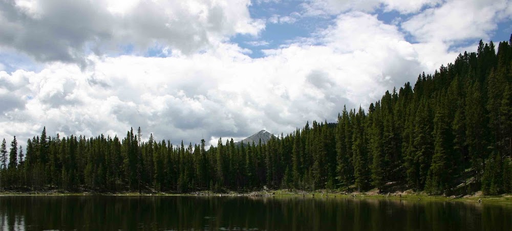
In a short distance we found another spot in which the ice cap was calving icebergs into another more remote lagoon. We could see the ice cap off in the distance and we noticed a road running from the ring road that looked passable. So I thought - what the hell let's give this a try. The road was a little rough but not too bad and before you knew it we were at a parking area and off in the distance we could see the glacier. When we arrived we had the entire place to ourselves so I was quick to scramble up the rocks to get a look at this immense river of ice. The climb over the rocks was tricky as everything was wet, but it was worth it as I got an intense view of the very end of the glacier. Looking further to the north I could see the bulk of the glacier looming in that direction. I started to climb even higher but then I recalled a memorial we had seen by the parking area to two German men who were lost in this glacier in 2007 and have never been found. That kind of stopped me in my tracks and made me climb back down to where Zack was waiting - as he had the smarts not to follow up up the rock face. We stayed about 20 minutes and then headed back to the car when another group showed up. We let them have the serenity and peace of this location to themselves.

(Zack in front of the glacier lagoon we had 100% to ourselves!)
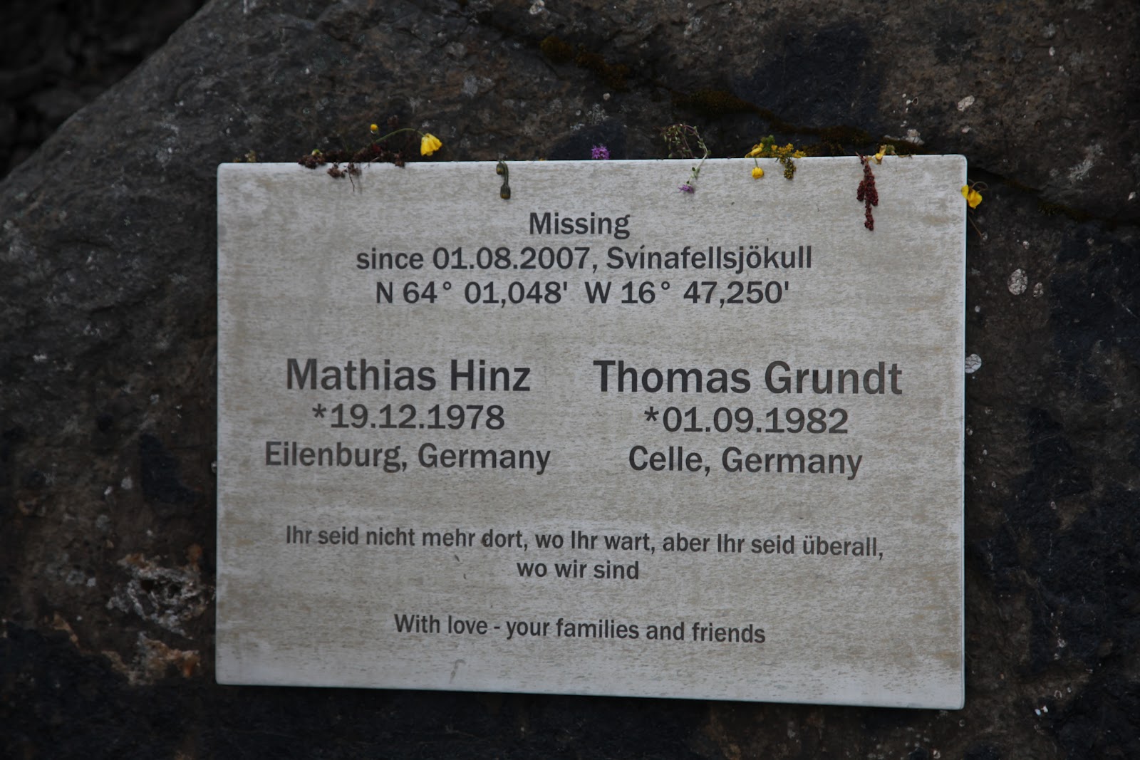
(Scary reminder that even if you are careful, bad things can happen.)
Continuing further east we saw brutal evidence of flooding
caused by a volcanic eruption under the ice cap. On September 30, 1996 a volcano under the ice
cap had erupted causing huge quantities of ice to melt in a very short amount
of time. The water was held up
underneath the ice cap in great lakes until it burst forth in a dramatic flood
on November 2, 1996. When the flooding
occurred it wiped out miles of the Ring Road and destroyed bridges built to
span the rivers flowing from the ice cap. Twenty thousand ton blocks of ice were swept
from the glacier out into the ocean in a matter of minutes. The remains of one of the bridges destroyed by
the flood have been left embedded in the sand and gravel to serve as an example
of the destructive power of the water.
The road continued through this no mans land of volcanic
sand and gravel plans for many, many kilometers until the impacts of the
glaciers and ice caps became less apparent upon the land. Traveling further west we came to the
beautiful town of Vik
and the natural beauty of the sea stacks found in the ocean on the outskirts of
town. Given this magnificent sight we
stopped to walk on the beach of black volcanic sand and take some pictures of
the sea stacks. Due to the beauty of
this small town I made the mental note that whenever I come back to Iceland in the
future, I need to make this town a several day stop.
Leaving Vik we began to turn to the north and started to
head further inland from the ocean. We
didn’t stop any more on the trip as it was now growing late and we wanted to
get to the guesthouse at which we were staying. The guesthouse was at a little place called Lambastadir. I can’t even say that it was a town as it was
more just a gathering of two farms. The
guesthouse was built on the property of a local farm. It was brand new and was in excellent
shape. We enjoyed it because it was
directly on the farm and we could see many of the farm animals as we pulled up
to check-in. It was truly a “mom and pop”
operation as the farmer and his wife were doing almost all the work to run the
place. I assume it allowed them to
supplement the income from just the farm.
To conclude our evening after checking in we drove another
10 kilometers or so to the town of Selfoss
to find some dinner. We had what I am
starting to consider the second Icelandic national food – pizza! It seems as though you can get pizza at just
about every restaurant in Iceland.
That is perhaps an exaggeration, but we
found pizza in most everywhere we stayed.
We then drove back to our guesthouse, used their Internet
connection for a while and then went to bed looking forward to another day of
adventure in Iceland! (A quick note upon that last statement – in most
of the hotels we have stayed there has been no television. We have normally not settled down in our
hotels until almost 9:00 or 10:00PM every night. But neither Zack nor I have wanted to go
immediately to bed so we have sat down and worked upon our computers. These times have traditionally been the times
I have spent writing these blog updates.
We don’t like spending time in our hotels but we do need an hour or two
of down time before we go to bed each night – and so we use the Internet to
stay in contact with the rest of the world. I am sure if there were TV we would probably
watch that instead, but that hasn’t even been an option.)
Anyway – that is it for now. I am still 2 days behind in my writing so this
is being writing on July 4th. Happy 4th of July to everyone. I hope it is a fun and safe day for you all.
Thanks and peace to all! ~J.
No comments:
Post a Comment